

Period: 01. 01. 2026 – 17. 11. 2027
Funding SOURCE: UM
PROJECT PARTNERS: University of Maribor: Faculty of electrical engineering and computer science, Faculty of Tourism, Faculty of Civil Engineering, Transportation Engineering and Architecture, Faculty of arts
PROJECT COORDINATOR: University of Maribor, Faculty of electrical engineering and computer science
GEMMA COORDINATOR: prof. dr. Domen Mongus
Earth Intelligence Program Core
Abstract:
The Earth Intelligence Program Core, led by Prof. Dr. Domen Mongus (UM FERI), connects researchers from four faculties of the University of Maribor (FERI, FT, FGPA, FF) into an interdisciplinary group. Key participating researchers include Assoc. Prof. Dr. Iztok Kramberger, Prof. DDr. Denis Đonlagić, Assoc. Prof. Dr. Maja Turnšek, Asst. Prof. Dr. Tomi Špindler, Asst. Prof. Dr. Jana Vilman, Prof. Dr. Vesna Žegarac Leskovar, and Prof. Dr. Gorazd Bajc. By integrating space technologies, advanced optical sensors, and geospatial artificial intelligence, the core will conduct six targeted research projects ranging from autonomous satellite navigation and sensor system development to applications in regenerative architecture, sustainable tourism, and heritage science. The primary strategic goal is to establish a shared research infrastructure for data-driven understanding of the Earth, which will serve as a foundation for international funding applications (e.g., Horizon Europe) and contribute to the green and digital transition.
Program Core: EARTH INTELLIGENCE
The Earth Intelligence program core, led by Prof. Dr. Domen Mongus (UM FERI), unites researchers from four faculties of the University of Maribor (FERI, FT, FGPA, FF) into an interdisciplinary group. Key participating researchers include Assoc. Prof. Dr. Iztok Kramberger, Prof. Ddr. Denis Đonlagić, Assoc. Prof. Dr. Maja Turnšek, Asst. Prof. Dr. Tomi Špindler, Asst. Prof. Dr. Jana Vilman, Prof. Dr. Vesna Žegarac Leskovar, and Prof. Dr. Gorazd Bajc.
By integrating space technologies, advanced optical sensors, and geospatial artificial intelligence (GeoAI), the core will conduct six targeted research projects. These range from autonomous satellite navigation and sensor system development to applications in regenerative architecture, sustainable tourism, and heritage science. The primary strategic goal is to establish a shared research infrastructure for data-driven Earth observation, serving as a foundation for international funding applications (e.g., Horizon Europe) and contributing to the green and digital transition.
Track Record and Key Projects
In the last decade, researchers within this core have successfully executed over 100 research projects in space technology and Earth data science. Notable examples include:
- PrAEctiCe: A Horizon Europe project developing a monitoring system for agro-ecological indicators in East Africa.
- GREEN.DAT.AI: A Horizon Europe project focused on energy-efficient AI infrastructures.
- PLOTO: A Horizon Europe project using spatial intelligence to improve the climate resilience of inland ports.
- SLAIF: A national development project establishing an “AI Factory” on supercomputing infrastructure.
- AID-HCH: An ARIS-funded project using AI to support cultural heritage and humanities research.
- IDEAL: An ARIS project that developed digital twins of agricultural ecosystems.
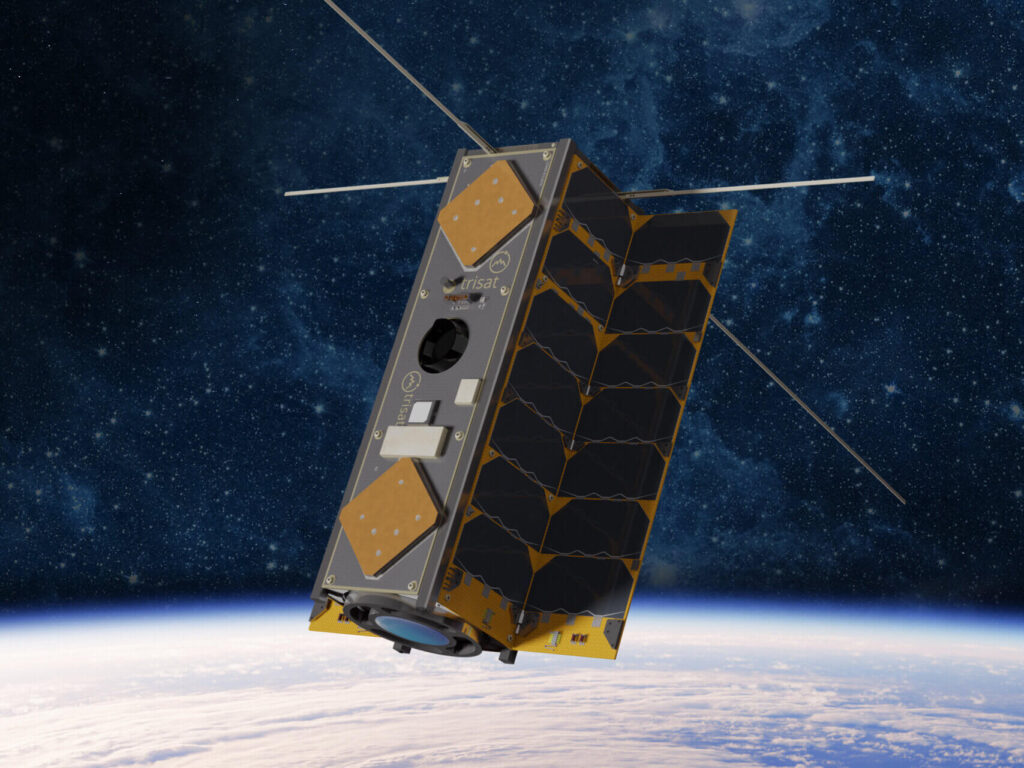
- TRISAT & TRISAT-R: ESA-backed missions demonstrating Slovenian space technologies in orbit, including radiation-tolerant systems (in collaboration with SkyLabs and CERN).
- U.S. Air Force Project: Development of high-resolution miniature optical fiber sensors for turbulence detection.
- H2020-FETOPEN (Magneliq): Development of new sensors for magnetic fields and mechanical quantities.
Technological Breakthroughs
The group has achieved several “state-of-the-art” milestones, including:
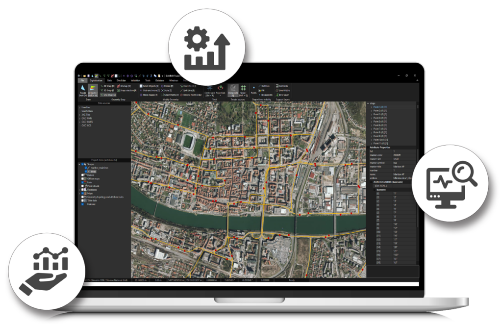
- GeMMA Fusion Suite: An analytical software framework for fusing heterogeneous data sources to power Earth Intelligence systems.
- TRISAT Platform: A highly miniaturized, low-energy satellite platform with onboard intelligence, following the Internet of Space Assets (IoSA) concept.
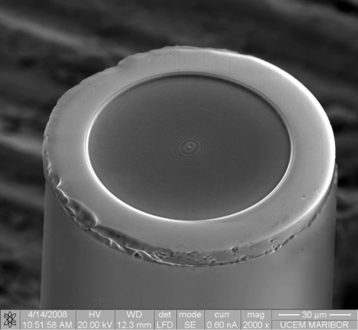
- Smallest Optical Pressure Sensor: Technology patented (US 7,684,657; US 8,559,770) and developed through a decade-long partnership with FISO Technologies.
Methodological advances have also been made in:
- Digital twin development and explainable feature learning.
- Radiation-hardened space technologies.
- Micro/nano-sensor manufacturing (transitional etching, structures on optical fiber tips).
- Carbon footprint modeling for tourism (NiST – STO) and heritage preservation via AI.
Key Research Pillars (Next 2 Years)
- Integrated Earth Intelligence Platform: Developing a central hub to integrate space tech, optical sensors, and open data.
- Visual Awareness for Autonomous Satellites: Creating methods for satellites to determine their position and orientation independently using image data and energy-efficient sensors.
- Advanced Optical Sensor Systems: Developing in-situ sensors to monitor traffic, energy patterns, and other Earth surface phenomena.
- Regenerative Architecture & Sustainable Built Environment: Using GeoAI to evaluate urban microclimates and energy efficiency for climate-resilient cities.
- Earth Intelligence for Tourism Studies: Identifying how satellite and spatial data can enhance sustainable tourism research.
- Geospatial AI for Heritage Science: Developing new methods to analyze historical contexts and intangible heritage within Slovenia and its border regions.
Future Outlook: The core plans to submit three Horizon Europe proposals related to “Data-driven Earth Understanding,” acting as the lead coordinator for one of these international consortia.